
PROGRESS UPDATE SEPTEMBER 2022
ICEM in partnership with GEOCE is implementing the World Bank Strengthening resilience of the road and drainage network in Nepal’s secondary cities project. The main objectives of the project are to (i) address challenges in planning, design and quality of road infrastructure in Nepal’s urban areas, (ii) support Pokhara and Urlabari municipalities in strengthening the linkages between road design, asset management, and risk and hazard mapping, (iii) contribute towards safeguarding the quality and sustainability of infrastructure investments under the World Bank’s Nepal Urban Governance and Infrastructure Project (NUGIP).
Throughout the first 10 months of the project a participatory approach has been successfully used to (i) build the capacity of Pokhara municipal engineers in hazard mapping and (ii) to obtain the most accurate and localised information on infrastructure and potential risks based on past experience and expert judgement concerning future impacts and hazards. This data forms a foundational part of the web-based Road Asset Management System (RAMS) for Pokhara (the first of its kind in Nepal), of which the draft version is anticipated by end of October. The project has received outstanding support from the Pokhara Mayor and CAO as well as active engagement from the municipal engineers, and with the continued strong support from NUGIP over the coming years the RAMS has solid potential to transform the maintenance and planning of road and drainage infrastructure from a reactive to a proactive approach.
Activity 1: Road and drainage asset management system with full integration of risk and hazard data for Pokhara
A key component of the project is to develop a web-based Road Asset Management System (RAMS) for Pokhara, including the integration of climate and disaster risk data. A RAMS is a web-based tool that primarily helps to plan asset maintenance, which includes (i) a map viewer where the details of individual assets can be displayed, (ii) an interactive asset inventory table where assets can be sorted by type, detail, and condition/status, and (iii) interactive road maintenance table to support prioritisation of road maintenance. The main steps completed to date to develop the RAMS include:
- Capacity needs assessment of future RAMS users and IT systems administrators at PMC.
- Participatory mapping of hazard areas and strategic infrastructure assets with PMC engineers and key stakeholders, overlaid with climate change parameters.
- Co-developed field-based survey data collection tool using KoboToolbox with twelve PMC engineers and provided three-day training on field survey techniques.
- Undertaken field survey to document strategic asset conditions in Pokhara as a key input to the RAMS.
- Developed frontend of RAMS including the map viewer and integrating of datasets from BIPAD (through consultation with NDRRMA).
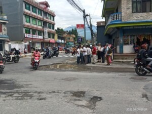
Figure 1: Pokhara engineers and ICEM/GEOCE conducting a field survey of road conditions in Pokhara in August 2022
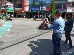
Figure 2: Pokhara engineers using KoboToolbox to survey road conditions in August 2022
Next steps include (i) finalise the backend of the RAMS including the road and asset condition tab and road maintenance tab, and testing of the system with PMC engineers, (ii) develop a training programme and materials for use and management of the RAMS platform for PMC’s IT section and engineers, and (iii) handover materials to NUGIP Urban Development Support teams for ongoing support to PMC during the NUGIP.
Activity 2: Vulnerability assessment for the prioritization of infrastructure
The second TA activity is to develop a climate vulnerability assessment (CVA) for Pokhara and Urlabari. The aim of the CVA within the project is to provide updated information on climate vulnerability and mainstream the consideration of climate change in road asset management and urban planning. To undertake the CVA, a participatory approach has been successfully used to (i) build the capacity of local engineers in hazard mapping and (ii) to obtain the most accurate and localised information on infrastructure and potential risks based on past experience and expert judgement concerning future impacts.
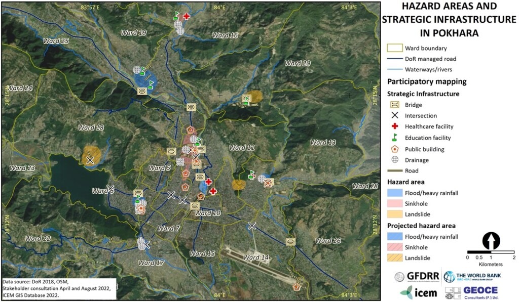
Figure 3: Example output of participatory hazard and infrastructure mapping in Pokhara
The latest participatory mapping workshop in Pokhara was covered on the national news, which can be found here.
The impact- and adaptive capacity assessment will be conducted in Pokhara late October. In Urlabari, the participatory mapping and the impact- and adaptive capacity assessment will be undertaken early November. Sections of the Pokhara CVA will be integrated into the Pokhara Road Asset Management System (RAMS) to inform and prioritize (i) the maintenance of roads and drainage and (ii) future infrastructure planning.
Activity 3: Best international practice design standards for urban roads and drainage in Nepal
A key component of the project is a review of the existing Nepali technical standards and guidelines as well as international best practice design standards for urban roads and drainage, specifically focusing on climate resilience. The review describes the strengths and weaknesses of current Nepali standards and guidelines and provides recommendations to further improve the current standards and guidelines framework, promoting resilient urban infrastructure design approaches. The aim is to provide evidence to inform future revisions and updates to national standards promoting the integration of climate resilience.
To disseminate the recommendations, The World Bank and ICEM convened a technical roundtable on Thursday, 11 August 2022, in Kathmandu, attended by senior government officials from federal, provincial and municipal agencies. During the roundtable, the review’s findings were presented, and detailed technical feedback from stakeholders on the recommendations was received, which were integrated in the final report.
Activity 4: Support for strengthening the institutional systems of municipalities for sustainable asset management
This activity focuses on preparing guidelines and training for road and drainage asset management at the municipal level and will be initiated upon (near) completion of the RAMS. It will be closely linked to the World Bank’s wider Nepal Urban Governance and Infrastructure Project, which will run until 2024 and provides a unique opportunity to ensure the sustainability of the RAMS.


Leave A Comment